 |
Tourist's Guide to Innsmouth(Originally published 1996; updated in 2021 and 2023) |
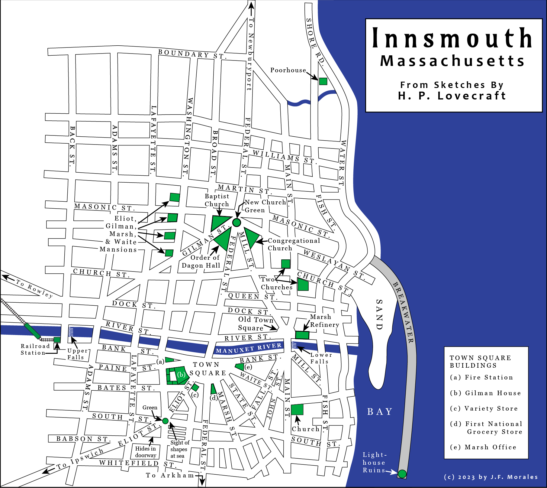
General Location
"You could take the old bus, I suppose," he said with a certain hesitation, "but it ain't much thought of hereabouts. It goes through Innsmouth—you may have heard about that—and so the people don't like it."
In their generally admirable annotated edition of "The Shadow Over Innsmouth" (Necronomicon Press, 1994), S. T. Joshi and David E. Schultz cite Lovecraft's statements that the fictional town of Innsmouth is inspired by the atmospheric, decaying town of Newburyport, Mass. But, as they also point out, Innsmouth itself is distinguished from Newburyport in the story, and is said to be located somewhere on the route from Newburyport to Arkham.
The exact location is a matter of some doubt. Joshi and Schultz point out that Innsmouth also shares some parallels with the real town of Gloucester, which is not mentioned in the story, and they imply that Lovecraft may have intended Innsmouth to be situated where Gloucester is. However, the evidence in the story convinces me that Innsmouth could not be located on the site of Gloucester. Consider:
The narrator sets out from Newburyport in Joe Sargent's bus, which proceeds south along the coast. The road splits from the main highway to Rowley and Ipswich, and veers toward the beach instead. The narrator sees Plum Island on the left, but eventually they pass the southern tip of Plum Island and he sees the open expanse of the Atlantic Ocean. Then the road begins to climb, and at the next crest, the valley of the Manuxet, with Innsmouth at its mouth, lies spread before them. Manuxet "joins the sea just north of the long line of cliffs that culminate in Kingsport Head and veer off toward Cape Ann" (the full story is available online here). Kingsport is another of Lovecraft's creations, but Cape Ann is real enough, and it happens that Gloucester is well around the corner beyond Cape Ann. Joe Sargent's bus simply hasn't driven that far.
There are other indications of a location too far north to be Gloucester. The Ipswich road is an extension of Eliot Street, which proceeds southwest from Town Square. Thus, when the narrator gazes west from his hotel room, planning his escape, he sees the Ipswich road to his left. The narrator also observes that the abandoned railway line to Rowley stretches off to the northwest.
So Innsmouth is supposed to be further south than Plum island, but not so far south as Cape Ann; also roughly southeast of Rowley and roughly northeast of Ipswich. Such a place would be perhaps near the mouth of the Ipswich river; one wonders if that river could be the inspiration for the Manuxet.
It is also quite possible that Lovecraft had no precise location in mind for Innsmouth, but the clues mentioned above seem to at least indicate the correct stretch of coast.
Lovecraft's Sketch Maps
Warning me that many of the street signs were down, the youth drew for my benefit a rough but ample and painstaking sketch map of the town's salient features... Thus I began my systematic though half-bewildered tour of Innsmouth's narrow, shadow-blighted ways.
What do we know about the specific layout of streets and buildings in Innsmouth? Joshi and Schultz's introduction to their 1994 annotated edition mentioned a surviving map by Lovecraft on the back of p. 14 of his handwritten manuscript, but stated that it "was executed hastily in pencil and thus has been found unsuitable for reproduction." When I wrote the first version of this article and created the accompanying map in 1996, I was working only from internal evidence in the story. In 2014, Leslie Klinger reprinted a small sketch map by Lovecraft in The New Annotated H. P. Lovecraft. I assumed that this was the map referred to by Joshi and Schultz. I later found a better reproduction of this map in a reprint of the Arkham House collection Something About Cats. In 2021, I revised the present article and also revised my own map to reflect this small sketch map.
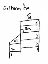
Imagine my surprise when on July 27, 2023, the artist Henri Desbois wrote to inform me that a more complete sketch map of Innsmouth by Lovecraft is available online as part of the digital repository of Brown University Library. It is included in their scan of the complete manuscript for "The Shadow Over Innsmouth," which turns out to include two separate sketch maps. The smaller map is the one that has been reprinted previously. The larger map is apparently the one that Joshi and Schultz found unsuitable for reproduction. As they stated, the map would be difficult to reproduce clearly on a printed page, because the original paper has turned brown and the pencil marks are mostly rather light; not to mention that Lovecraft's handwriting is close to illegible. Lovecraft's manuscript also includes a sketch of Gilman House and the buildings behind it. To the best of my knowledge, Henri Desbois is the first person to create a map of Innsmouth based on Lovecraft's full sketches. He has also created a charming version of the map in a 19th century style. I am most grateful to M. Desbois for having brought his maps, and Lovecraft's originals, to my attention. I have now redrafted my own map to also be consistent with Lovecraft's full plan.
Now that Lovecraft's own sketch maps are freely available, certain previous attempts at Innsmouth maps have become obsolete. These include an influential map by Eric Carlson, first published in Nyctalops 6 (Feb 1972) and reprinted in The New Annotated H. P. Lovecraft. It is a nicely drawn map and reflects evidence from the story. However, Carlson also supplies a number of street names that are not mentioned by Lovecraft, including Southwick Street, Pierce Street, Garrison Street, Hancock Street, Phillips Place, and Place of Hawks. Of these, "Place of Hawks" was the name of one of August Derleth's books, and also the name of his custom-built house. Since neither the book nor the home existed when Lovecraft wrote "The Shadow Over Innsmouth," it is clear that Carlson was deliberately including elements of later origin. A redrawn version of this map is available on the Internet and is described as "Map by Carolyn Schultz, Incorporating Material by Tani Jantsang, As Adapted from the Nyctalops Map by Eric Carlson, And as Originally Drawn by H. P. Lovecraft." The implication may be that the extra street names come from some sequel written by the well-known horror author Tani Jantsang. These maps are still of interest as original creations, but not as guides to Lovecraft's intended geography.
Even Lovecraft's own sketch maps must be viewed with some caution. They were not published with the story originally. Lovecraft wrote several drafts of this story; part of one such early draft survives. It deviates from the published story in small ways, notably by mentioning a Father Iwanich who does not appear in the final version. Lovecraft's preliminary notes for the story also survive, and they also are not completely consistent with the final story. Naturally the question arises, did Lovecraft follow his own sketch maps strictly when he wrote the final draft of the story?
To answer this question, let us follow the narrator's progress as recounted in the story, and compare it at each step with Lovecraft's sketch maps.
Specific Layout
As he approaches Innsmouth from the north on Joe Sargent's bus, the narrator notes the steeples and belfries of some of the major buildings, and the tendency of increased decay toward the waterfront. He also notes a stone breakwater with a ruined lighthouse, and tongue of sand with cabins, dories, and lobster pots. The orientation of the breakwater is not described, except that "the only deep water seemed to be where the river poured out past the belfried structure and turned southward to join the ocean at the breakwater's end." All this is consistent with Lovecraft's map, except that the map does not show the ruined lighthouse. In my own map, I have placed the lighthouse ruins at the tip of the breakwater, because Lovecraft refers to "...an ancient stone breakwater...at whose end were what looked like the foundations of a bygone lighthouse."
The map shows a poorhouse at the northeast edge of town. The story tells us later that this is where Zadok Allen lives. On the map, there are a pair of squiggly lines that pass by the poorhouse to the south. These could be interpreted as a stream or possibly as a meandering dirt road. I've coloured it blue on the assumption that Lovecraft meant it to be a stream.
As the bus proceeds into town, it reaches an "open concourse or radial point" which we later find out is called New Church Green. The Order of Dagon Hall is located at the right-hand junction. Across the street from it is a church, through whose basement door the narrator glimpses the "robed, shambling form" that makes such a horrific impression. We later learn that this is the Congregational Church. A third, Baptist church in the Green is also mentioned later. All this is consistent with Lovecraft's map, which also clarifies the relative positions of the churches.
Presently the bus passes over a bridge, and the narrator sees "two vigorous sets of falls upstream on my right and at least one downstream on my left." Lovecraft's map indicates "Upper Falls" near Adams Street, but doesn't specify that they are "two vigorous sets." The lower falls are shown on Lovecraft's map just east of the Main Street bridge.
Then the bus rolls into a "semicircular square" across the river; we later find out this is called Town Square. The hotel of sinister repute, Gilman House, is located on the right (west) side. The narrator lists the buildings in the square in this order: First National grocery, restaurant, drug store, wholesale fish-dealer's, and Marsh Refinery Company office. The latter is specified as being at the easternmost extremity of the square. Since the narrator is standing at Gilman House, on the west side of the square, it seems likely that he is listing the buildings in order from west to east. Lovecraft's own map only shows three of these buildings: Gilman House on the west, the office to the east, and another building to the south with a scribbled name that might be "F Nat" for First National. The grocery boy tells the narrator that the street he came in on is Federal.
The narrator notes that, looking eastward from Town Square, he "could catch blue glimpses of the harbour, against which rose the decaying remains of three once beautiful Georgian steeples." On the map, Lovecraft indicates these steepled churches by drawing a pointy triangle sticking out of each one. One of the churches is shown in the southeast quadrant of the town, on Main Street, and is indeed located between Town Square and the harbor. The other two are shown on the map in the northeast quadrant, at the intersection of Main Street and Church Street. When viewed from Town Square, these churches would appear with the ocean in the background rather than the harbor. Doubtless the view from Town Square was partially obscured by buildings, so the narrator can be excused for thinking that he was seeing glimpses of the harbor behind the two northeastern steeples.
The narrator crosses the Federal Street bridge back to the northern side of the river and proceeds toward the lower falls, passing the Marsh refinery and noting the "open confluence of streets" which form the Old Square. Lovecraft's map portrays the Marsh refinery as completely blocking River Street, which seems a bit unlikely. I suspect that Lovecraft simply ran out of drawing space, and that he actually intended the refinery to be between River Street and the river bank. However, my map leaves the refinery in the middle of River Street as he drew it.
Our hero crosses back to the south on Main Street bridge and enters a "region of utter desertion" with "collapsing huddles of gambrel roofs." It is not clear how far south he proceeds, but he does see "the ghoulish, decapitated steeple of an ancient church," which may be the church at the intersection of Main Street and Waite Street. He then proceeds east, possibly on on Waite Street or South Street. The narrator views portions of Fish Street and Water Street and crosses the river to the north again, this time using the Water Street bridge.
After traversing some suspiciously atmospheric terrain, the narrator finds himself admiring two old churches at the corner of Main and Church Streets. The map shows that Main runs north/south, and Church runs east/west. The narrator considers that his "next logical goal" is New Church Green. However, overcome by a desire to avoid "robed, shambling" churchgoers, the narrator keeps north on Main to Martin, and proceeds west, crossing Federal Street well north of the Green.
Now he enters the stately neighborhood of northern Broad, Washington, Lafayette, and Adams Streets, then proceeds south on Washington. The grocery clerk had previously told him:
The Marshes, together with the other three gently bred families of the town—the Waites, the Gilmans, and the Eliots—were all very retiring. They lived in immense houses along Washington Street...
The narrator apparently sees these mansions, without being sure which one belongs to which family:
In Washington Street there was a row of four or five [mansions] in excellent repair and with finely tended lawns and gardens. The most sumptuous of these—with wide terraced parterres extending back the whole way to Lafayette Street—I took to be the home of Old Man Marsh, the afflicted refinery owner.
Unfortunately, Lovecraft's map does not show these mansions. From the story, we only learn that they are in a row on Washington Street. In my map, I have arbitrarily placed them on the west side of Washington Street, in the stretch between Martin Street and Gilman Street.
The narrator proceeds south on Washington to the river, and on reaching it, notes the railway station and covered railway bridge upstream. After crossing the Washington Street bridge, he turns on Paine Street toward Town Square. Then he sees the fire station on the left, with the crazed Zadok Allen hanging out on a bench in front. Lovecraft's map does not show the fire station.
Seized by some perverse imp of dark, hidden sources, the narrator proceeds to a "dingy variety store just off the square in Eliot Street," there to procure some bootleg liquor. Lovecraft's map does not show the variety store. However, since Gilman House occupies the west side of Eliot Street, I have placed the variety store on the east side.
The narrator entices old Zadok to follow him along Waite Street, which runs south-east toward the waterfront. They turn south on Water Street and eventually settle down on some rocks near a wharf, just south of a deserted warehouse that blocks the breakwater from view. Lovecraft's map does not indicate where the conversation took place, and it seems likely that the map does not extend far enough south to show it.
Later, "seeking a route I had not traversed before, I chose Marsh Street instead of State for my return to Town Square." Back in Town Square, our unlucky narrator is coerced into staying over at Gilman House, where he checks into fourth-story rear room with a westward view. The room overlooks a courtyard that is entirely surrounded by buildings (it does not let directly out into a street). Lovecraft left this side view of Gilman House among his notes:
When he makes his escape from the room later, he proceeds through the connecting rooms to the north, hoping to reach the roofs of buildings on Paine Street. The nearest streets that he contemplates reaching are Paine, Washington, or Bates. He prefers to avoid Paine because he doesn't want to risk being seen from the fire-station. He climbs down to an adjoining building that abuts Paine Street to the north, the courtyard to the south, and Washington Street to the west. He heads south on Washington, crosses Bates street, and continues to where Washington intersects both an east/west street called South and Eliot Street, which runs to the southwest.
The open space was, as I had expected, strongly moonlit; and I saw the remains of a park-like, iron-railed green in its centre.
Looking east on South Street, the narrator sees "intermittent flashes of light on the distant reef" and "a teeming horde of shapes swimming inward toward the town." Lovecraft's map at this point has a notation that is difficult to read, but seems to say "Sight of shapes at sea."
On perceiving that the southern exit on Federal toward Arkham is likely to be blocked, the narrator decides to make for the abandoned train line to Rowley. He decides to proceed there indirectly, in order to avoid recrossing the conspicuous intersection of Washington, South, and Eliot. He crosses to the west side of Washington, then makes a right turn on Babson St. There,
I clung as closely as possible to the sagging, uneven buildings; twice pausing in a doorway as the noises behind me momentarily increased.
At the corresponding point in Lovecraft's map, there is a note that reads "hides in doorway."
The narrator turns north on Lafayette, west on Bates, north on Adams, and left on Bank Street. He then follows Bank to the railway station. Lovecraft's smaller sketch map shows the station just to the west of a bridge, but doesn't provide any name for the bridge. In my map, I have interpreted it as Back Street, the westernmost of the north/south streets shown in Lovecraft's larger sketch map.
The tracks emerge from the far (west) side of the station, follow the river for some distance, and then cross over. (To save space, my map shows the railroad bridge as being nearer than it probably should be.) The narrator crosses the rickety railroad bridge. On the north side, he crosses River Street.
Proceeding along the old tracks, he approaches a point where the Rowley road crosses over and pursues a course further to the west. Here he witnesses the parade of "croaking, baying entities of unknown source" and faints dead away. The next day he continues on to Rowley.
Overall, the finished story matches with Lovecraft's sketch maps very well. When I drew the original version of my map, the story itself provided enough information to picture the progress of the story and the course of the narrator's escape. But by drawing on Lovecraft's sketch maps, this new version of my map includes fuller and more accurate detail than was possible before. Lovecraft's geographic plans add greatly to the richness of the narrative and the sense it conveys of Innsmouth as a real place, rooted firmly in New England history but harboring the most unholy secrets of a vast, indifferent cosmos.
Return to Cthulhu Files home page
Send comments to jfm.baharna@gmail.com.
© Copyright 1996-2023 by Joseph Morales.